|
Catalog | Order | Support | Index | Contact | Home | ||||||||||
|
|
|
|
|
|
|
|||||||||||
| USA Relief | Tech Spec | Catalog | Guide | Download | License | |||||||||||
USA Relief Catalog - The State of Arizona
Map Specifications for the State of Arizona
| Map identification: | Arizona | Projection system: | Geographic / Plate Carree |
| Map coverage: | State of Arizona | North boundary: | 38º North |
| Image size (pixels): | 8400 x 8400 pixels | South boundary: | 31º North |
| Map size at 300 dpi: | 28 x 28 inches | East boundary: | 108º West |
| Map size at 100 dpi: | 112 x 112 inches | West boundary: | 115º West |
| Resolution per pixel: | 100 meters | Scale (300 dpi): | 1:1,000,000 |
| RGB file size: | 212 Mb | Scale (72 dpi): | 1:400,000 |
| CMYK file size: | 282 Mb | Vertical interval: | 100 meters |
| Grayscale file size: | 71 Mb | Vertical exaggeration: | 3 times normal |
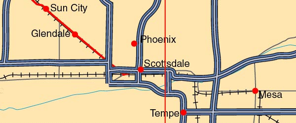
 Detail view of EPS Vector Map of Arizona - the land fill color is switched on. The EPS Vector map for Arizona has 26 layers which may be individually modified or removed. Select the Vector only EPS map of Arizona option to download this style map. |
 Overview of the Adobe Illustrator Vector EPS map with multiple editable layers. Any of the 5 relief styles may be used as alternative background textures to customize this map. |

